

About the Project
Overview & Benefits
The I-5 Rose Quarter Improvement Project will improve safety and congestion where three major interstates converge and reconnect the Albina neighborhood with the construction of a cover over a portion of I-5.
The 1.8-mile project area contains the only two-lane section of I-5 in a major urban area between Canada and Mexico. It has the highest crash rate on any urban interstate in Oregon and is the state's top traffic bottleneck. The project addresses the critical need to keep Oregon's people and economy moving.
Project Improvements
Select an improvement feature to learn more.
- Auxiliary Lanes and Shoulders
- I-5 Southbound Off-Ramp Relocation
- Highway Cover
- Hancock Crossing
- Multimodal Local Street Improvements
- Pedestrian and Bicycle Bridge
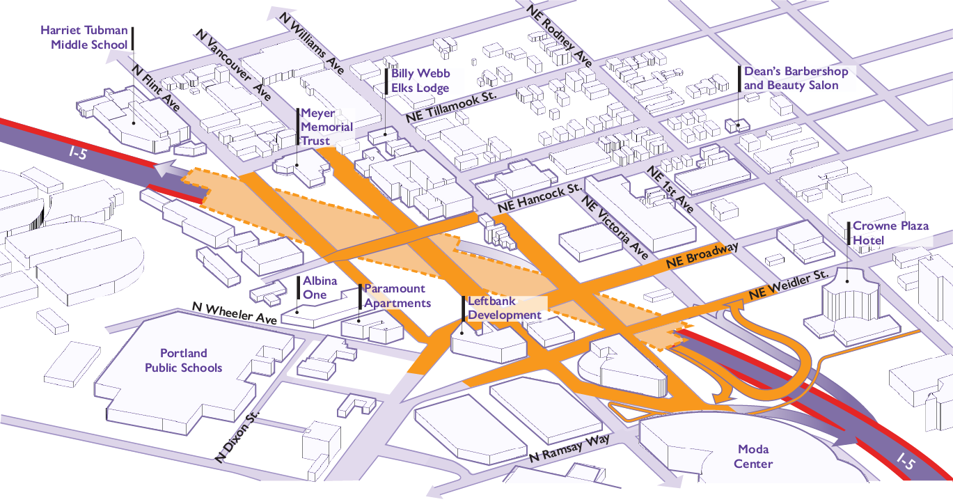
New ramp-to-ramp connections on I-5 between I-84 and I-405 with wider shoulders will improve safety and reduce congestion at the state’s top bottleneck.
Relocation of the I-5 southbound off-ramp from Vancouver/Broadway to the south will connect it with NE Williams Avenue and NE Weidler Street.
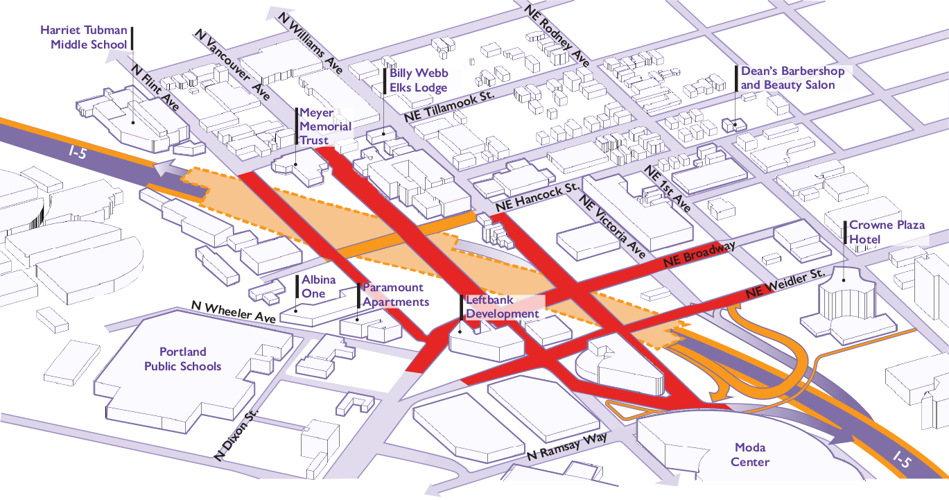
A new highway cover over I-5 will reconnect local streets and create new community spaces on top for future development and economic opportunities.
A new east-west roadway crossing over I-5 will reconnect Hancock Street across the highway, adding another crossing north of Broadway/Weidler.
A variety of street improvements will enhance conditions for people walking, biking and rolling.
A car-free bridge will create a new path over I-5 to connect with the walking and biking network.
Please note that this graphic is conceptual, and the project design and cover shape may change as design progresses.
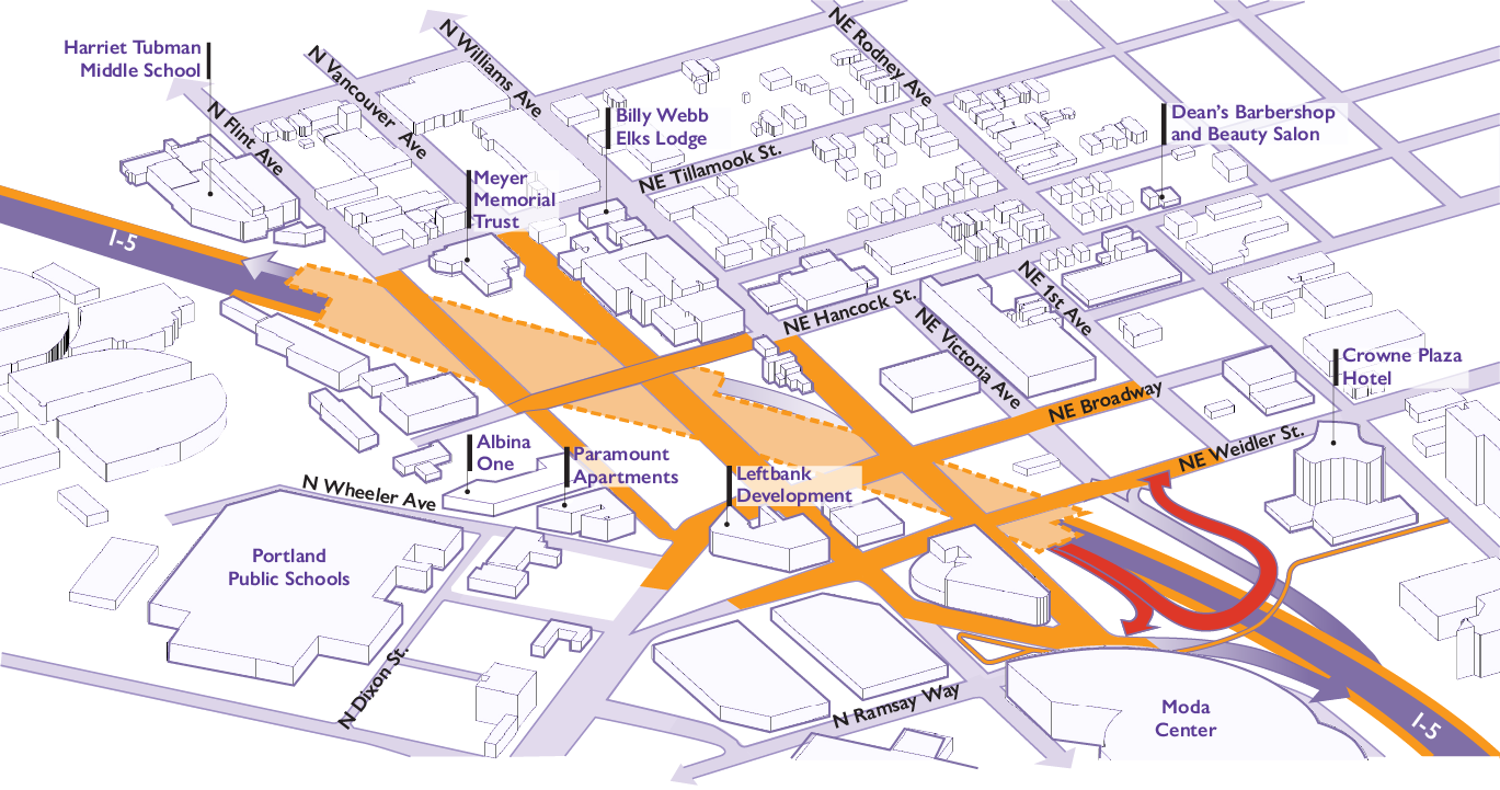
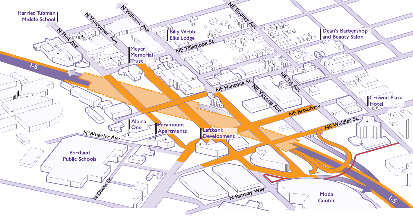
Auxiliary Lanes and Shoulders
The project will build new ramp-to-ramp connections in each direction between I-84 and I-405, called auxiliary lanes. The northbound auxiliary lane will connect from the I-84 ramp to the I-405 and Greeley Avenue exits. The southbound auxiliary lane will connect from the Greeley Avenue and I-405 ramps to the I-84 and Morrison Bridge exits.
Why Auxiliary Lanes: Three interstates (I-5, I-84 and I-405) converge in the short distance between the Morrison and Fremont bridges. The closely spaced interchanges and narrow shoulders create:
- The worst traffic bottleneck in the state of Oregon
- The highest crash rate of any Oregon urban interstate
- The 27th worst freight bottleneck in the nation
Ramp-to-ramp connections (auxiliary lanes) reduce vehicle weaving by creating safer merging opportunities and improved connections between interchanges. With a new auxiliary lane in each direction, drivers will experience safer, more reliable travel with less potential for crashes. An estimated one-third of traffic will be able to stay on these ramp-to-ramp connections to travel between interstates instead of merging and causing congestion and safety issues. Adding expanded shoulders will provide space for disabled vehicles to move off the road and allow emergency vehicles to respond more quickly.
Auxiliary Lanes in Action: ODOT research has shown that auxiliary lanes are an effective way to improve safety and reduce bottleneck congestion. For example, a new auxiliary lane on I-5 addressed the southbound bottleneck from OR 217 to I-205, improving traffic flow. The auxiliary lane reduced congestion from five hours a day to one hour a day, saving drivers an estimated $8.4 million dollars in cost of delay each year. In the Portland metro area, ODOT has completed or is planning to complete auxiliary lane projects on I-5 and I-205.
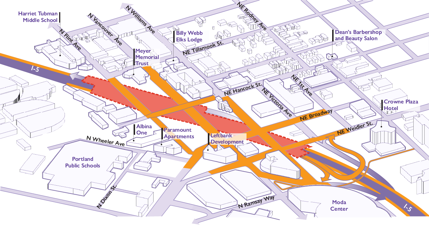
I-5 Southbound Off-Ramp Relocation
The project is moving the existing off ramp from I-5 southbound at Vancouver/Broadway closer to the Moda Center. Drivers heading to the east will be routed to a newly constructed I-5 “flyover” ramp to connect with Weidler. Drivers heading west will be routed to the intersection of Ramsay and Wheeler near the Moda Center. The off-ramp relocation moves freeway traffic away from pedestrians, bicyclists and local traffic to increase safety and support redevelopment. This feature was incorporated into the project in response to public comments.
Highway Cover
A cover will be built over I-5, similar to a very wide bridge. By replacing existing overcrossings with one continuous highway cover, space will be available for community development. In addition, the new cover will include seismic upgrades, making the structure over I-5 more resilient than existing overcrossings in the event of an earthquake.
The highway cover will connect streets that are currently divided by I-5 and add new land, allowing wider sidewalks and new spaces for community activities. Once built, the highway cover will be able to support buildings up to three stories, depending on the final design. It will also provide critical transportation access for community members and first responders.
Community-led Design: An Independent Cover Assessment in 2020 through 2021 evaluated multiple designs for the proposed highway cover. The Proposed Hybrid 3 Cover Concept, now the current project design, received the strongest community support because it was viewed as the most effective in supporting the community's vision for a revitalized Albina neighborhood. The Historic Albina Advisory Board, Albina Vision Trust, the City of Portland, TriMet, Metro and Multnomah County all endorsed this highway cover design. In 2024, the project received federal approval from the Federal Highway Administration to proceed with this cover design, enabling the project to move into more detailed design and construction.
Please note that this graphic is for illustrative purposes only and does not represent a final design; the highway cover development process will be led by the City of Portland, in partnership with ODOT, with strong community involvement.

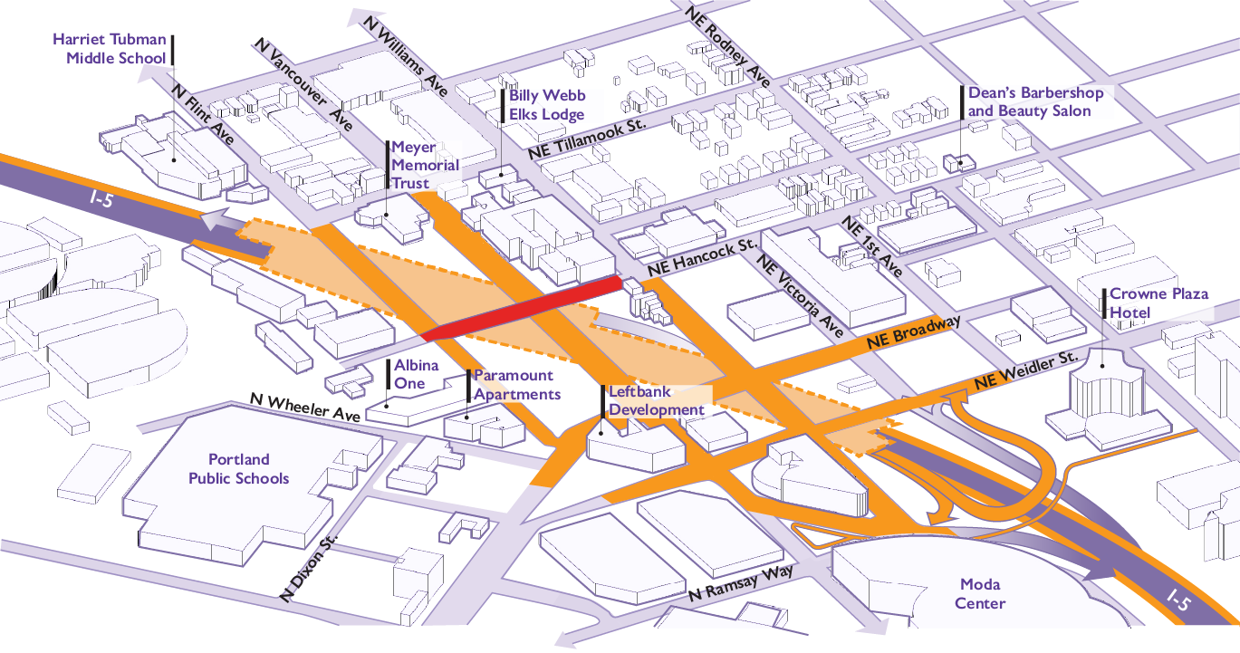
Hancock Crossing
The highway cover will reconnect Hancock Street across I-5. Currently, there are few east-west connections over I-5 in the area. The community recommended the Hancock Crossing as an additional east-west connection for accessing current and future destinations in Lower Albina.
This new crossing will include space for people walking, biking and rolling, creating a safe and more connected option in the Albina neighborhood.
Multimodal Local Street Improvements
Local street improvements will make streets safer by offering greater visibility, protection and access to people walking, biking and rolling through the Rose Quarter area. Upgrades to sidewalks will include curb ramps that comply with the Americans with Disabilities Act (ADA) and additional street lighting. New protected bike lanes will add enough space for cyclists to move along N Williams Street, one of the city's busiest bikeways.
Pedestrian and Bicycle Bridge
A car-free bridge will create a new path over I-5 to connect with the walking and biking network. This project element was added based on public comments related to pedestrian safety.
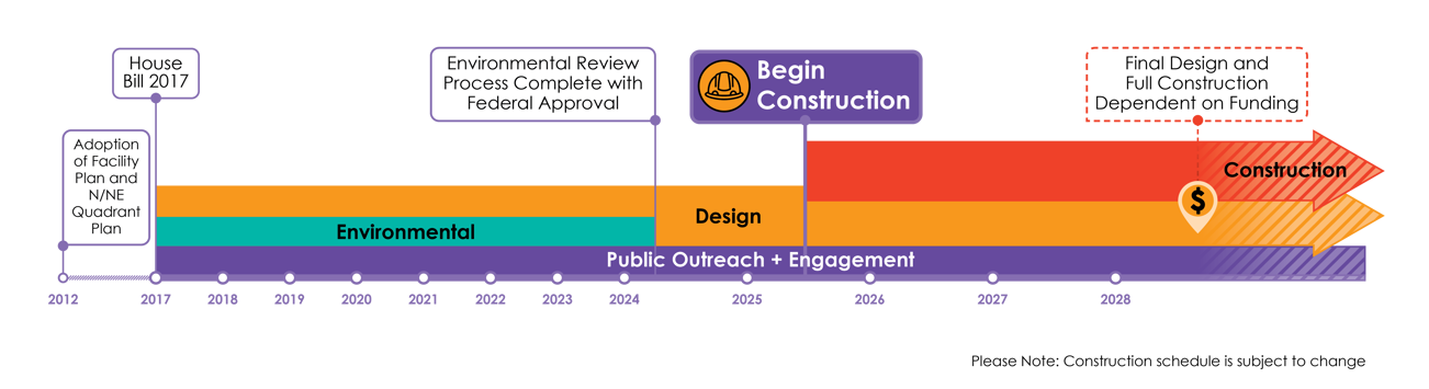
Project Timeline
Project Benefits
The I-5 Rose Quarter Improvement Project will improve roadway conditions for everyone in the project area. Currently, congestion affects the region’s economy, resulting in reduced economic competitiveness because businesses are unable to reliably move their goods and services through the project area.
On average 11,700 trucks (10% of average daily traffic) and about $115 million in commodities travel through the Rose Quarter corridor every day. The regional cost of congestion is estimated at $250M annually.
The investments will:
- Reduce congestion and delays on I-5 benefitting the regional economy and improving the movement of goods and people.
- Improve safety and congestion on I-5 and on surrounding local streets where three major interstates converge.
- Restore community and neighborhood street connections over I-5 by redesigning overpasses.
- Design and build a highway cover that can accommodate new community development and enhanced public space.
- Create opportunities for building long-term career prospects for small businesses.
Current Traffic & Safety Challenges - Traffic & Safety Improvements
Challenge
Top traffic bottleneck in Oregon and the 27th worst freight bottleneck in the nation as of 2025
Improvement
Smoother traffic flow on I-5 through ramp-to-ramp connections and wider shoulders
Challenge
Crash rates 3.5 times higher than similar urban interstates in Oregon
Improvement
Up to 50% reduction in crashes on I-5
Challenge
12 hours of congestion each day on average impacts the economy and makes travel on I-5 less reliable for drivers and freight movement
Improvement
Save travelers on I-5 nearly 2.5 million hours of travel time and the regional economy an estimated $250 million each year, getting people, goods and freight through this section of highway more quickly
Challenge
Lack of full shoulders on I-5 in many spots make it difficult to clear accidents and for emergency vehicles to respond quickly
Improvement
Faster emergency response times as responders use wider shoulders to move through traffic
Challenge
Lack of safe and accessible pedestrian and bike facilities make walking, biking and rolling challenging and dangerous
Improvement
Local street improvements to make streets safer by offering greater visibility, protection and access for people walking, biking and rolling
Project Values
-
Restorative Justice for the Albina Community to accelerate social, racial and economic equity, sustaining positive tangible change specifically for Portland's Black community.
-
Community Input & Transparent Decision-Making to have community-informed and involved decision-making through a community-connected, transparent and inclusionary process.
-
Mobility Focus to increase connectivity for the traveling public and local community.
-
Climate Action & Improved Public Health to reduce greenhouse gas emissions and meet local, regional and statewide climate action goals.
ODOT acknowledges the impact and harm caused to the historic Albina community by the initial construction of I-5. We are committed to supporting a safer and more equitable project for Albina.